
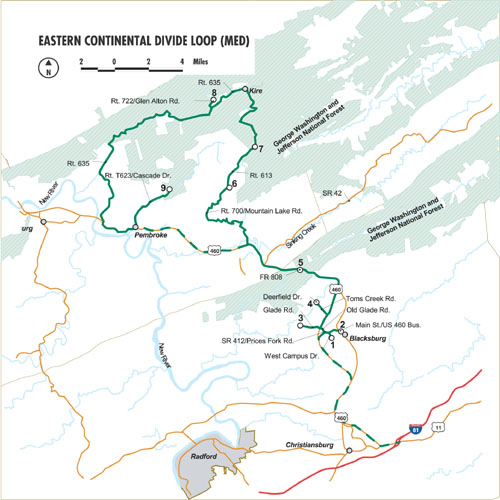
Sites On This Loop
- MED01: Virginia Tech Campus and Smithfield Plantation Area
- MED02: Virginia Tech Museum of Natural History – This site has been withdrawn from the VBWT
- MED03: Heritage Community Park and Natural Area
- MED04: Deerfield Trail
- MED05: Pandapas Pond
- MED06: Mountain Lake Lodge
- MED07: War Spur Trail
- MED08: Glen Alton
- MED09: Cascades
Description
Beginning in the college town of Blacksburg, the Eastern Continental Divide Loop takes visitors northwest towards the West Virginia border. This loop is so named because sites occur on either side of the Eastern Continental Divide. See clear evidence of the divide in the flow of Craig Creek, whose waters spill into the James River, joining it as the river flows east into Chesapeake Bay and the Atlantic Ocean. Neighboring Poverty Creek flows westward, emptying into the New River, which continues to its confluence with the Ohio River, and finally to the Mississippi River. The unique birding opportunities of this area will be of special interest to many nature enthusiasts. Many of these sites can be spectacularly productive for breeding neotropical migrants such as scarlet tanager and black-throated blue warbler. This loop has a nice assortment of forest, private, conservancy, and public lands, as well as a site of academic stature — a museum! Undoubtedly, any interested birder is likely to get an “unofficial” lifer or two while browsing the museum’s expansive collection. Other unusual features about this loop include Mountain Lake – the only naturally occurring lake in the mountains of Virginia. Here, spring-fed pristine waters remain at cool temperatures year-round. The Cascades offers nature trails that meander alongside Little Stony Creek, which flows from the same plateau as Mountain Lake.
Loop Map
Services
Blue Ridge Travel Association
276.619.5003
info@virginiablueridge.com
Giles County Chamber of Commerce
540.921.5000
gcc@I-plus.net
Montgomery Regional Tourism Office
540.394.2120
bleakleyts@montgomerycountyva.gov
New River Valley
540.763.2196
jamisonr@swva.net